It was but a few days ago that we were in single digit temperatures with wind shills in the negative teens. What’s in store for tomorrow? We’re going to have a high temperature of 57º with not only rain, but flooding rains and thunderstorms. Don’t believe me? First, Take a look at this map.
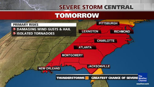
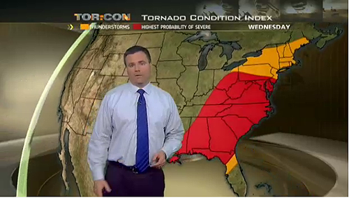
Still don’t believe me? Well if you don’t believe me, how about believing this guy from The Weather Channel.
STILL don’t believe me or The Weather Channel guy? Fine…here’s the National Weather Service warning:
Issued by The National Weather Service
Binghamton, NY
8:15 pm EST, Tue., Jan. 29, 2013
… FLOOD WATCH REMAINS IN EFFECT FROM WEDNESDAY EVENING THROUGH THURSDAY MORNING…
THE FLOOD WATCH CONTINUES FOR
* PORTIONS OF NEW YORK AND NORTHEAST PENNSYLVANIA… INCLUDING THE FOLLOWING COUNTIES… IN NEW YORK… DELAWARE… OTSEGO AND SULLIVAN. IN NORTHEAST PENNSYLVANIA… LACKAWANNA… LUZERNE… NORTHERN WAYNE… PIKE… SOUTHERN WAYNE AND WYOMING.
* FROM WEDNESDAY EVENING THROUGH THURSDAY MORNING
* HEAVY RAIN AND SNOW MELT WEDNESDAY EVENING WILL CAUSE RISES IN AREA STREAMS AND RIVERS.
* THE GREATEST RISK FOR FLOODING WILL BE ALONG SMALL STREAMS AS HEAVY RAIN OVER A SHORT PERIOD CAUSE RAPID RISES. MAIN STEM RIVERS WILL ALSO RISE BUT ONLY MINOR FLOODING IS EXPECTED AT THIS TIME.
PRECAUTIONARY/PREPAREDNESS ACTIONS…
A FLOOD WATCH MEANS THERE IS THE POTENTIAL FOR FLOODING ON SMALL STREAMS… CREEKS… POOR DRAINAGE… URBAN AND LOW-LYING AREAS BASED ON CURRENT FORECASTS. YOU SHOULD MONITOR LATER FORECASTS AND BE ALERT FOR POSSIBLE FLOOD WARNINGS. THOSE LIVING… WORKING OR DRIVING IN AREAS PRONE TO FLOODING SHOULD BE PREPARED TO TAKE ACTION SHOULD FLOODING DEVELOP.
&&
More Information
… HEAVY RAIN AND MILD AIR ARE HEADED FOR THE REGION…
.A STRONG STORM SYSTEM IS DEVELOPING OVER THE CENTER OF THE COUNTRY AND WILL PUSH MILD AIR AND RAIN INTO THE REGION ON WEDNESDAY. SOME OF THE RAIN WILL BE HEAVY WEDNESDAY EVENING. THIS RAIN… IN COMBINATION WITH MELTING SNOW … COULD CAUSE FLOODING OF SMALL STREAMS AND MINOR FLOODING OF THE RIVERS IN THE REGION.
Still don’t believe me after all of that? I don’t know what to tell you. It’s all the proof I have of this upcoming storm.
So here comes the point where I tell you what The Official Twev1701 Weather Forecast will be. I believe the official forecast 100%. I believe that we are not only going to have rain, but several inches. That, in conjunction with the warm temperatures melting what snow and ice is left, along with the frost in the ground, is going to create an incident like we had back in 1996. Back then, a warm spell in conjunction with a major rain storm thawed everything and all the thaw from New York came down the Susquehanna and was kind enough to flood us out. In fact, that was the first time I had ever seen a flood here. Sadly, it was not my last and I would eventually see a storm that shadowed the Great Flood of ’72.
In a nutshell kids, grab your umbrella and goulashes — it’s going to be a wet one for the next 2 days!